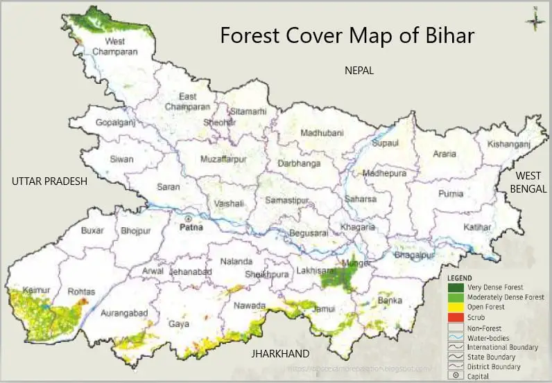
■ Forest Cover of Bihar:
• Geographical Area (GA): 94,163 sq km
• Very Dense Forest (VDF): 333.42 sq km
• Moderately Dense Forest (MDF): 3,285.83 sq km
• Open Forest (OF): 3,761.54 sq km
• Total Forest Cover: 7,380.79 sq km i.e 7.84% of GA (To remember- GCHO.GI & G.HD%)
Change in forest cover w.r.t ISFR 2019 = 75 sq km i.e. 1.03% increase; the highest increase was seen in OF= 69 sq km followed by MDF =6 sq km, while VDF remained the same.
• Scrub: 235.89 sq km
(Note: Scrub areas are not part of Forest Cover.)
S.No. | Class | Area (in sq Km) | Percentage of GA |
1 | VDF | 333.42 | 0.35 |
2 | MDF | 3285.83 | 3.49 |
3 | OF | 3761.54 | 4.00 |
4 | Total | 7380.79 | 7.84 |
5 | Scrub | 235.89 | 0.25 |


Area under Forests:
• Recorded Forest Area (RFA) as per the State’s records is 7,442 sq km (i.e 7.90% of GA)
The Forest Cover inside and outside RFA has been analysed in different categories as follows:

Top districts in terms of Forest Cover area-wise:
- Kaimur (Bhabua): 1051.56 sq km
- West Champaran: 903.34 sq km
- Rohtas: 669.91 sq km
- Jamui: 661.17 sq km
- Gaya: 602.55 sq km
Top districts in terms of Forest Cover as a percentage of geographical area:
- Kaimur: 31.56%
- Jamui: 21.34%
- Nawada: 20.72%
- Munger: 20.16%
- West Champaran: 17.28%
Bottom districts in terms of Forest Cover area-wise:
- Sheikhpura: 1.19 sq km
- Arwal: 4.14 sq km
- Jehanabad: 4.43 sq km
- Buxar: 5.89 sq km
- Siwan: 7.66 sq km
Bottom districts in terms of Forest Cover as a percentage of geographical area:
- Sheikhpura: 0.17%
- Buxar & Siwan: 0.35%
- Gopalganj 0.42%
- Jehanabad 0.48%
- Arwal 0.65%
Maximum increase/decrease in Forest Cover: (Change w.r.t 2019 assessment)
Maximum increase:
- Banka (16.29%)
- Jamui: (13.22%)
- Gaya: (12.24%)
Maximum decrease:
- Kaimur (-4.83%)
- Supaul: (-4.46%)
- Rohtas: (-2.32)
Maximum area under:
• Very Dense Forest: West Champaran (249.34 sq km)
• Moderately Dense Forest: West Champaran (548.47 sq km)
• Open Forest: Kaimur (Bhabua) (531.73 sq km)

Forest Fire:
• Highest number of forest fire incidents was reported in Valmiki Tiger Reserve (VTR-2) forest division.


Tree Cover:
• Tree Cover: 2,341 sq km i.e. 2.49% of GA
• Tree cover of Bihar has increased by 338 sq km i.e 16.87% increase as compared to the previous assessment reported in ISFR 2019.
• Total Forest + Tree Cover = 9721.79 sq km i.e. 10.3% of GA
• Extent of Trees Outside Forest (TOF): 4,891 sq km
Trees outside Forests (TOF) refer to tree resources found outside the forests as defined in the Government records. Forest Cover outside the recorded forest area is derived using boundaries of RFA or Green Wash.

Dominant tree species in Trees Outside Forests (TOF)
")
Growing Stock in Forest:

Carbon Stock in Forest:


Growing Stock of Bamboo:

Major Invasive Species:

©https://bpscexamprep.com/