The Ministry of Environment Forest and Climate Change has recently released the India State of Forest Report (ISFR), 2021.
Note: The India State of Forest Report (ISFR) 2023 is not yet released.
ISFR is a biennial publication of the Forest Survey of India (FSI) which has been mandated to assess the forest and tree resources of the country. The first State of Forest report was brought out in the year 1987. The current report, ISFR-2021 is 17thin the series and presents the latest status of the ‘Forest cover’ and ‘Tree cover’ of the country, estimates of growing stock, extent of trees outside forests, mangrove cover, bamboo resources and assessment of forest carbon stock. This time, a special chapter on Forest cover assessment in Tiger reserves and Tiger corridor areas of the country and decadal change in Forest Cover has also been included.
The National Forest Policy 1988 mandates that 33% of the geographical area of India should be under forest or tree cover. FSI, has been assessing forest cover since 1987 and tree cover since 2001. For this purpose, isolated trees and small patches of trees, which are less than 1 hectare in area and found outside Recorded Forest Areas (RFA), are considered for assessment.
■ Findings of the Report
■ Forest Cover:
★• The totalForest Cover of the country, as per the current assessment is 7,13,789 sq km which is 21.71 per cent of the total geographical area of the country.
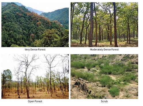
• In terms of canopy density classes, area covered by VDF is 99,779 sq km (3.04%), MDF is 3,06,890 sq km (9.33%) and OF is 3,07,120 sq km (9.34%).
• In the current assessment, Very Dense Forest and Moderately Dense Forest together constitute 57 per cent of the total Forest Cover of the country.
★• There is an increase of 1,540 sq km (0.22%) of Forest Cover in the country as compared to the previous assessment 2019.
• Increase in forest cover has been observed in Open Forest followed by Very Dense Forest.
•The Gain in Forest Cover or improvement in forest canopy density may be attributed to better conservation measures, protection, afforestation activites, tree plantation drives and agroforestry.
• Forest cover inside the RFA/GW has shown a slight increase of 31 sq km whereas there is an increase of 1,509 sq km of forest cover outside the RFA/GW as compared to the previous assessment of 2019.
• Forest cover in the hill districts of the country is 2,83,104 sq km, which is 40.17% of the total geographical area of these districts. The current assessment shows a decrease of 902 sq km (0.32%) in 140 hill districts of the country.
• The total forest cover in the tribal districts is 4,22,296 sq km, which is 37.53% of the geographical area of these districts. The current assessment shows a decrease of 655 sq km of forest cover inside the RFA/GW in the tribal districts and an increase of 600 sq km outside.
• The forest cover in the North-Eastern region is 1,69,521 sq km, which is 64.66% of its geographical area. The current assessment shows a decrease of forest cover to the extent of 1,020 sq km (0.60%) in the region.
• 17 States/UT’s have above 33 per cent of the geographical area under forest cover. Out of these states and UT’s, five states/UTs namely Lakshadweep, Mizoram, Andaman & Nicobar Islands, Arunachal Pradesh and Meghalaya have more than 75 per cent forest cover while 12 states/UTs namely Manipur, Nagaland, Tripura, Goa, Kerala, Sikkim, Uttarakhand, Chhattisgarh, Dadra & Nagar Haveli and Daman & Diu, Assam, Odisha, have forest cover between 33 percent to 75 percent.
★Top States/UTs having largest Forest Cover area wise:
Madhya Pradesh
Arunachal Pradesh
Chhattisgarh
Odisha
Maharashtra
★Top States/UTs in terms of Forest Cover as a percentage of the total geographical area:
Mizoram (84.53%)
Arunachal Pradesh (79.33%)
Meghalaya (76.00%)
Manipur (74.34%)
Nagaland (73.90%)
■ Tree Cover:
★• The total Tree Cover of the country has been estimated 95,748 sq km, which is 2.91 per cent of the total geographical area of the country.
• Tree Cover (patches of size less than 1 ha outside recorded forest area) in the country has increased by 721 sq km (0.76%) as compared to 2019 assessment.
★Top States/UTs having maximum Tree Cover area wise:
Maharashtra (12,108 sq km)
Rajasthan (8,733 sq km)
Madhya Pradesh (8,054 sq km)
Karnataka (7,494 sq km)
Uttar Pradesh (7,421 sq km)
★Top States/UTs in terms of Tree Cover as a percentage of the total geographical area:
Chandigarh (13.16%)
Delhi (9.91%)
Kerala (7.26%)
Goa (6.59%)
Jammu & Kashmir (6.43%)
■Forest & Tree Cover Assessment:
★• The total Forest and Tree Cover of the country is 80.9 million hectare which is 24.62 per cent of the geographical area of the country.
• Compared to the assessment of 2019, there is an increase of 2,261 sq km (0.28%)in the total forest and tree cover of the country. Out of this, the increase in the forest cover has been observed as 1,540 sq km and that in tree cover is 721 sq km.
■ Gains and Losses in Forest Cover in States & UTs.
States/UTs showing Gain in Forest Cover:
Andhra Pradesh (647 sq km)
Telangana (632 sq km)
Odisha (537 sq km)
Karnataka (155 sq km)
Jharkhand (110 sq km)
Note: Compared to 2019 assessment, the highest percentage increase of Forest Cover in India is seen in Telangana (3.07%), followed by Andhra Pradesh (2.22%) and Odisha (1.04%).
States/UTs showing Loss in Forest Cover:
Arunachal Pradesh (257 sq km)
Manipur (249 sq km)
Nagaland (235 sq km)
Mizoram (186 sq km)
Meghalaya (73 sq km)
Note: Compared to 2019 assessment, the highest percentage decrease of Forest Cover in India is seen in Nagaland (-1.88%).
■ Mangrove cover
• Total mangrove cover in the country is 4,992 sq km, which is 0.15% of the country’s geographical area.
• An increase of 17 sq Km in mangrove cover has been observed as compared to the previous assessment of 2019.
★• Top three states showing mangrove cover increase are:
Odisha (8 sq km)
Maharashtra (4 sq km) and
Karnataka (3 sq km).
• There is no change in mangrove cover in Kerala, Tamil Nadu, A&N Islands, D&NH and Daman & Diu and Puducherry.
• Growing Stock is the volume of all living trees in a forested area. The total Growing Stock of wood in the country is estimated at 6,167.50 million cum which comprises of 4,388.15 m cum inside forest areas and 1,779.35 m cum outside recorded forest areas (TOF).
• There is a total increase of 251.74 m cum (4.26%) in the growing stock of the country as compared to the estimates reported in ISFR 2019.
• Total carbon stock in country’s forest is estimated to be 7,204 million tonnes, and there an increase of 79.4 million tonnes in the carbon stock of country as compared to the last assessment of 2019. The annual increase in the carbon stock is 39.7 million tonnes.
Source: IPCC, GPG
• Soil Organic Carbon is the largest pool of forest carbon accounting for (55.67%) followed by AGB (32.20%), BGB (9.98%), Litter (1.49%) and dead wood (0.66%). On comparing the changes between present and previous assessment, maximum changes have been observed in AGB and dead wood.
■ Bamboo Resources:
Bamboo forests have grown from 13,882 million culms (stems) in 2019 to 53,336 million culms in 2021.
■ Assessment of Forest Cover in Tiger Reserves and Lion Conservation Area
For the first time, ISFR-2021 has assessed forest cover in tiger reserves, tiger corridors and the Gir forest which houses the Asiatic lion.
• The Wildlife Protection Act, 1972 (2006 amendment) provides for the declaration of an areas as Tiger Reserve for the in-situ conservation of Tigers. A Tiger reserve comprises of a core area, which is kept as inviolate for the purpose of Tiger conservation and the peripheral areas constitutes the buffer, which is a multiple-use area, with preference to conservation over other land uses, thereby maintaining an equilibrium between wildlife and human activities for the purpose of livelihood, developmental, social and cultural rights of the local people.
• Tiger Corridors constitute areas linking one Tiger Reserve with another Tiger Reserve, allowing movement of Tigers, prey and other wildlife.
The Forest Cover of 2021 assessment, was analyzed within Tiger reserves in three canopy density classes namely, Open Forest, Moderately Dense Forest and Very Dense Forest. Scrub, which is not a part of the forest cover, has also been recorded.
The Tiger reserves occupy an area of approximately 74,710.53 sq km, which is 2.27% of the country’s geographical area.
The current assessment shows that the forest cover in the Tiger reserves is 55,666.27 sq km, which is 7.80% of the country’s forest cover and 74.51% of the total area of Tiger reserves.
• Nagarjunasagar Srisailam Tiger Reserve in Andhra Pradesh has the largest forest cover (2,932.95 sq km) followed by Simlipal in Odisha (2,562.86 sq km) and Indravati in Chattisgarh (2,377.28 sq km).
• In terms of forest cover as percentage of the area of Tiger reserves, top five Tiger reserves are:
Pakke in Arunachal Pradesh (96.83%)
Achanakmar in Madhya Pradesh (95.63%)
Simlipal in Odisha (94.17%)
Kali in Karnataka (92.45%)
Dampa in Mizoram (92.05%)
• Tiger corridors comprise 14,289.39 sq km, which is 0.43% of the country’s geographical area.
• Forest cover in the tiger corridors is 11,575.12 sq km, which is 1.62% of the country’s total forest cover.
• The forest cover in tiger corridors has increased by 37.15 sq km (0.32%) between 2011-2021, but decreased by 22.6 sq km (0.04%) in tiger reserves.
• 20 Tiger reserves have recorded an overall gain in forest cover during the past decade whereas 32 Tiger reserves have recorded an overall loss in forest cover.
• Buxa (West Bengal), Anamalai (Tamil Nadu) and Indravati (Chhattisgarh) reserves have shown an increase in forest cover while the highest losses have been found in Kawal (Telangana), Bhadra (Karnataka) and the Sunderbans (W.B) reserves.
• The Asiatic lion (Panthera leo persica) is listed as ‘Endangered species‘ on the IUCN Red List. Gir forest of Gujarat is the only natural habitat of the lion in India. Located in Junagadh district, Gir National Park (NP) and Wildlife Sanctuary (WLS) comprises a total area of 1,412.13 sq km. It is part of the Indo-Malayan Ecoregion Kathiarbar-Gir Dry Deciduous Forests.
• Forest cover within Gir NP and WLS was observed to be 1,295.34 sq km, accounting for 85.20% of the Digitized Boundary.
■ Climate Change:
• The report estimates that by 2030, 45-64% of forests in India will experience the effects of climate change and rising temperatures, and forests in all states (except Assam, Meghalaya, Tripura and Nagaland) will be highly vulnerable climate hot spots.
• Ladakh (forest cover 0.1-0.2%) is likely to be the most affected.
• India’s forests are already showing shifting trends of vegetation types, such as Sikkim which has shown a shift in its vegetation pattern for 124 endemic species.
■ Forest Fires:
• In India, severe fires occur in many forest types particularly dry deciduous forest, while evergreen, semi-evergreen and montane temperate forests are comparatively less prone.
• The forest fire season in the country is normally from Nov to June, and with majority of fires being caused due to man-made factors. During fire season, the following country-wide forest fire related services are being provided:
Near Real-Time Forest Fire Monitoring
Large Forest Fire Monitoring
Early Warning Alert based Forest Danger Rating System
FSI Van Agni Geo-portal
Identification of Fire Prone Forest Areas
Sharing of WMS (Web Map Service) & WFS (Web Feature Service) services to State Forest Departments.
• Forest Survey of India (FSI) has been alerting State Forest Departments towards forest fire incidences detected by MODIS (Moderate Resolution Imaging Spectro-radiometer) sensor on-board Aqua and Terra Satellite of NASA and SNPP-VIIRS (Suomi National Polar-orbiting Partnership- Visible Infrared Imaging Radiometer Suite) sensor, at least six times in 24 hours. The fire hotspots detected by MODIS and SNPP-VIIRS sensors are received at Shadnagar Earth station (National Remote Sensing Centre) and processed using standard algorithm. The fire hotspots are electronically shared with FSI, which are further processed automatically at FSI headquarter Dehradun and alerts are generated and disseminated to the registered end users.
• In fire season 2020-21, the total hotspots detected by MODIS sensor were 52,785 and SNPP-VIIRS sensor were 3,45,989.
• The survey has found that 35.46 % (100-64.54 =35.46) of the forest cover is prone to forest fires.
• Out of this, 2.81 % is extremely prone, 7.85% is very highly prone and 11.61 % is highly prone.
• The highest numbers of fires were detected in Odisha, Madhya Pradesh and Chhattisgarh.
Reserved Forest (RFs): An area so constituted under the provisions of the Indian Forest Act, 1927 or other State Forest Acts, having full degree of protection. In Reserved Forests, all activities are prohibited unless permitted.
Protected Forest (PFs): An area notified under the provisions of the Indian Forest Act, 1927 or the other Forest Acts, having a limited degree of protection. In the protected forest all activities are permitted unless prohibited.
Forest Area: The area recorded as forest in the Government records. It is also referred to as Recorded Forest Areaor RFA. Besides RFs and PFs, the RFA include all such area, which have been recorded as forests in the revenue records or have been constituted so under any State Act or Local Laws. Forest Area has a legalrelevance.
Unlike the forest cover, the recorded forest areas do not have the actual forest canopy cover on the ground.
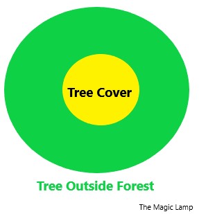
Trees Outside Forest (TOF): It refers to all trees growing outside RFA irrespective of patch size.
Tree Cover: It means patches of trees as well as isolated trees outside the RFA on areas less than one hectare (0.01 Km2). Tree cover includes trees in all formations including scattered trees.
Tree cover is part of Tree Outside Forest.
The Trees included in Tree Cover constitute only a part of TOF and therefore, the former is a subset of the latter.
Forest Cover: Forest cover reported in ISFR includes all lands having trees more thanone hectarein area withtree canopy density of more than 10%, irrespective of ownership, the legal status of the land and species composition of trees. Forest cover does not have a legal status but has a geographical status.
■ Forest cover classified in terms of tree canopy density as:
Non-forest lands not included in any of the above classes. (includes water)
• Green Wash: It is the extent of wooded areas generally shown in light green colour on the Survey of India toposheets. It represents the forested areas at the time of survey for preparing such topographic sheets. It has been used as a substitute to RFA in respect of those States and UTs form where the usable digitized boundaries of recorded forest areas could not be made available to Forest Survey of India.